Don't forget to turn in any books you have checked out during lunch.
Geography for Life
Wednesday, May 29, 2013
Thursday, May 23, 2013
23, 28 May - Geography of Middle Earth, part 3
Announcements: You will be getting your packets of missing work today. The hard deadline for missing work is 29 May (Wednesday). If you think you have turned something in, but it is noted as missing, please check the return basket for it.
Also, DO NOT FORGET TO RETURN YOUR BOOKS! The book room is open for students to return books during lunch.
Geography of Middle Earth: Paths
The Path which Bilbo and the Dwarves take to the Lonely Mountain.
Geography of Middle Earth: Real World Connections
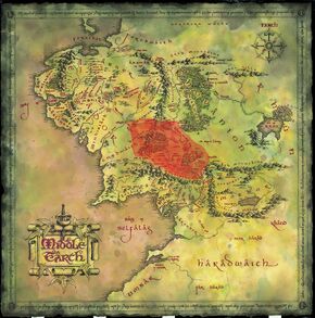
Middle Earth Map - Populated
Map of Middle Earth:
Another interpretation of Middle Earth:
 |
| http://bigthink.com/strange-maps/121-where-on-earth-was-middle-earth |
A further interpretation of Middle Earth:
 |
| http://arminius1871.deviantart.com/art/Europe-is-middle-earth-262329986 |
One last idea of where the map comes from:
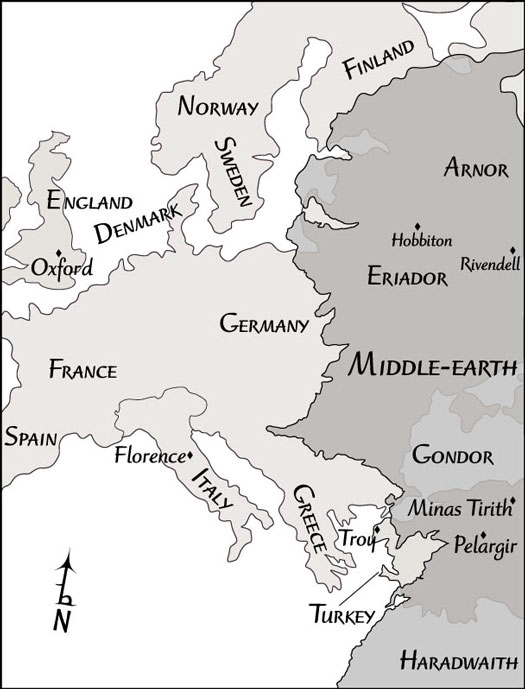 |
| http://www.dummies.com/how-to/content/exploring-the-diverse-lands-of-middleearth.html |
But then why was New Zealand chosen for the filming location?
Let's take a look: Behind the Scenes Journey through Middle Earth
Tuesday, May 21, 2013
21-22 May - Geography of Middle Earth, part 2
Announcements:
1) I am offering extra credit to anyone who can find the two missing (new) Goode's Atlases.
2) Many of you will be asked to come to Wednesday intervention this week to make up missing work.
3) I will be holding a Middle Earth discussion group during 1st lunch on Thursday (23 May) in my room. All are welcome to join.
Mountains and Caves
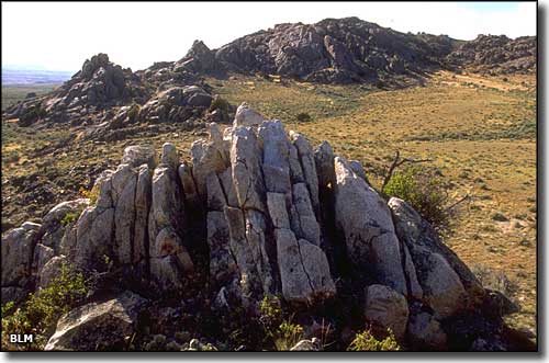
The Lonely Mountain (Erebor) is the kingdom and homeland of the dwarves. We saw that it contained veins of gold where the dwarves are digging. Gold veins are commonly found in greenstone belts.The rocks in a greenstone belt are sometimes metamorphic (changed through high heat and pressure) and sometimes igneous (volcanic). The Seminoe Moutains in Wyoming are part of the greenstone belt.
The Iron Hills are part of a hilly mountainous region east of the Lonely Mountain. Thorin's cousin Dane and his kingdom reside there.
Iron is commonly found in sedimentary rock alongside quartz as part of banded iron formations. These red rocks are the kind we would expect to find in the Iron Hills.
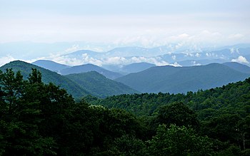
The Blue Mountains are the current kingdom of the dwarves under the rule of Thorin. We could expect these to be like the Blue Ridge Mountains (part of the Appalachians). The "blue" comes from the release of isoprene from deciduous trees (like oak and poplar).
Misty Mountains - central mountain chain through which Bilbo and the dwarves must travel to get to the Lonely Mountain. The Fellowship of the Ring also passes through the Misty Moutains, by way of Moria (Khazad-dûm).
Both times the parties go through the mountains by going under them. Moria is another under-mountain kingdom built by the dwarves, but in the Hobbit, the dwarves and Bilbo go through the Goblin Kingdom. This kingdom may have been somewhat mined for expansion, but looks as though it was built from an existent cave system.
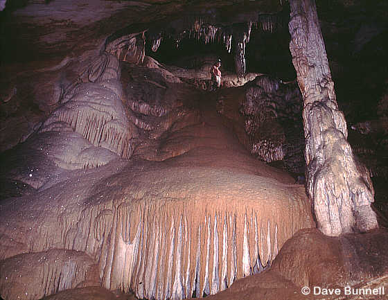
Most caves are solution caves formed in karst. Karst is rich in limestone, which gets eroded dripping water over time.
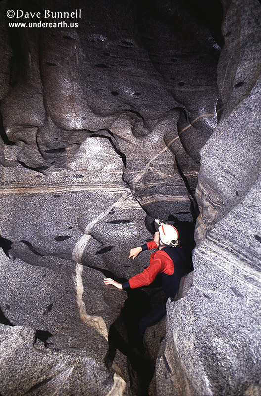
The caves that we see in the Hobbit, however, are most likely hard rock erosion caves. These caves are likely to happen in granite (igneous rock). Usually water erodes existent cracks and creates passage ways and crevices like we will see in the movie.
Friday, May 17, 2013
17, 20 May - Geography of Middle Earth, Day 1
Announcements:
Current Event > (if submitted)
Geography of Middle Earth
Physical Features:
Middle Earth (or Endor in Quenya - the language of the high elves)
A continent in Tolkien's world (Arda) in which humans, elves, dwarves, hobbits, orcs, dragons, etc live.
Shire - British term for a division of land, much like a county, usually presided over by a single sheriff
6 Cultural Traits: Dwarves vs. Hobbits
Fill out the chart with aspects of dwarven and hobbit culture. We will use this chart to compare the two different kinds of culture.
Concerning Hobbits
Current Event > (if submitted)
Geography of Middle Earth
Physical Features:
Middle Earth (or Endor in Quenya - the language of the high elves)
A continent in Tolkien's world (Arda) in which humans, elves, dwarves, hobbits, orcs, dragons, etc live.
Shire - British term for a division of land, much like a county, usually presided over by a single sheriff
In Middle Earth, The Shire is the land in which Hobbits live. It is mostly pastoral countryside.Downs - hill or hill fort
The Far Downs, North Downs and South Downs are part of and surround the Shire.Dale - a valley
We will see images of a city called Dale that is in a valley at the foot of the Lonely Mountain, to which the dwarves are journeying. Dale built on a lake.Dell - a small valley, usually with trees
Tolkein uses this term as a part of names, like Rivendell (think "river valley", The Last Homely House, where Elrond resides). There are many waterfalls and trees in the hidden valley in which Rivendell lies.Wood - literally woods, or a forest
Mirkwood is a forest that Radagast lives in/near. Dol Guldur (the ruined castle where Radagast finds the Necromancer) is at the southern end of Mirkwood.Other geographical features in Tolkien's world:
- The Lonely Mountain (Erebor)
- Mount Doom (volcano), which is on the Plateau of Gorgoroth in Mordor
- Dead Marshes (Golem, Frodo and Sam travel through these to get to Mordor)
- Fords of Isen (where the Ring Wraiths are swept away by the river as Frodo tries to escape from them, near Rivendell)
- Bay of Belfalas
6 Cultural Traits: Dwarves vs. Hobbits
Fill out the chart with aspects of dwarven and hobbit culture. We will use this chart to compare the two different kinds of culture.
Concerning Hobbits
Wednesday, May 15, 2013
15-16 May - China and Tests
Announcements: Those that still need to make up tests will take them today. Everyone else will get their tests back today.
Moving Forward Poll
Current Event >
Use the Goode's atlases to find the ten locations above.
Moving Forward Poll
Current Event >
Spy scandal in Moscow evokes an earlier era
First Opium Wars: Locations
Guangzhou (gwang - joe) - Also known as "Canton", this was initially the only port at which Western ships were allowed to dock and do business.
Beijing (bay - ging) - the capital city of the Qing Dynasty
Nanjing (nan - ging) - the location of the signing of the Unfair Treaty
Jinjiang (gin- gee-ong) - the location of a major store of grain for the Imperial Court
Yangtze River (yahg - zee) - Also known as "Chang Jiang", this is the longest river in China and the principle water route within the country. It was used by the British gunboat to approach the capital.
Hong Kong - The island ceded by China to the British following the First Opium War. It was the first fully British colony in China.
Additional Ports that opened up following the signing of the Unfair Treaty in 1842:
Shanghai (sh ahng - high)
Ningbo (ning- bow)
Fuzhou (foo - joe)
Xiamen (she-ah-men)
Use the Goode's atlases to find the ten locations above.
Monday, May 13, 2013
13-14 May - China
Announcements: You will be getting your tests back this week. There will be an opportunity to earn back half credit on test questions you have missed (not including extra credit).
Current Event >
The First Opium War in China
Map Activity:
Locate the relevant cities and landforms on your map.
Current Event >
Rat meat and Chinese food safety
http://www.bbc.co.uk/news/magazine-22467484The First Opium War in China
Map Activity:
Locate the relevant cities and landforms on your map.
Wednesday, May 1, 2013
1-2 May - Test Review
Announcements:
1) Current events map is due today. You should have at least 8 current events on it.
2) Reporting for the British Empire: Draft to the Editor is due today. Remember to attach your illustration!
3) Today (1 May) is the last day to turn in any late work for the first part of the term.
4) Today we will begin reviewing for the test that will be on the 9th and 10th of May.
Current Event > One Minute World News (4 Headlines) - http://www.bbc.co.uk/news/video_and_audio/
Review for the Test - Study Guide
Today we will start our test review. You will fill out the study guide today in class. You will be expected to bring it back on the day of the test (9th or 10th of May) to be turned in for a grade.
In small groups, use your notes to fill in the study guide.
Answer the first four sections (everything before mercantilism) on the study guide. You will have about 20 minutes to work on this section.
--
Answer the next three sections (mercantilism and Industrial Revolution) on the study guide. You will have about 20 minutes to work on this section.
--
Fill in the chart with the 6 cultural traits and an example of each from the British Empire. Consider asking people what topics they are writing about for their articles to help you. You will have 20 minutes to work on this section.
Subscribe to:
Comments (Atom)

