Current Event > (if submitted)
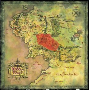
Geography of Middle Earth
Physical Features:
Middle Earth (or Endor in Quenya - the language of the high elves)
A continent in Tolkien's world (Arda) in which humans, elves, dwarves, hobbits, orcs, dragons, etc live.
Shire - British term for a division of land, much like a county, usually presided over by a single sheriff
In Middle Earth, The Shire is the land in which Hobbits live. It is mostly pastoral countryside.Downs - hill or hill fort
The Far Downs, North Downs and South Downs are part of and surround the Shire.Dale - a valley
We will see images of a city called Dale that is in a valley at the foot of the Lonely Mountain, to which the dwarves are journeying. Dale built on a lake.Dell - a small valley, usually with trees
Tolkein uses this term as a part of names, like Rivendell (think "river valley", The Last Homely House, where Elrond resides). There are many waterfalls and trees in the hidden valley in which Rivendell lies.Wood - literally woods, or a forest
Mirkwood is a forest that Radagast lives in/near. Dol Guldur (the ruined castle where Radagast finds the Necromancer) is at the southern end of Mirkwood.Other geographical features in Tolkien's world:
- The Lonely Mountain (Erebor)
- Mount Doom (volcano), which is on the Plateau of Gorgoroth in Mordor
- Dead Marshes (Golem, Frodo and Sam travel through these to get to Mordor)
- Fords of Isen (where the Ring Wraiths are swept away by the river as Frodo tries to escape from them, near Rivendell)
- Bay of Belfalas
6 Cultural Traits: Dwarves vs. Hobbits
Fill out the chart with aspects of dwarven and hobbit culture. We will use this chart to compare the two different kinds of culture.
Concerning Hobbits

No comments:
Post a Comment