Current Event > (if submitted)
Geography of Middle Earth
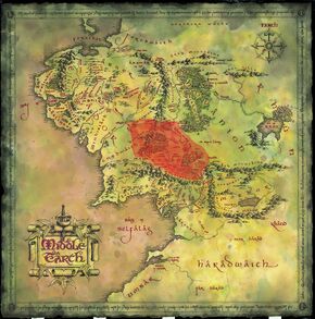
Physical Features:
Middle Earth (or Endor in Quenya - the language of the high elves)
A continent in Tolkien's world (Arda) in which humans, elves, dwarves, hobbits, orcs, dragons, etc live.
Shire - British term for a division of land, much like a county, usually presided over by a single sheriff
In Middle Earth, The Shire is the land in which Hobbits live. It is mostly pastoral countryside.Downs - hill or hill fort
The Far Downs, North Downs and South Downs are part of and surround the Shire.Dale - a valley
We will see images of a city called Dale that is in a valley at the foot of the Lonely Mountain, to which the dwarves are journeying. Dale built on a lake.Dell - a small valley, usually with trees
Tolkein uses this term as a part of names, like Rivendell (think "river valley", The Last Homely House, where Elrond resides). There are many waterfalls and trees in the hidden valley in which Rivendell lies.Wood - literally woods, or a forest
Mirkwood is a forest that Radagast lives in/near. Dol Guldur (the ruined castle where Radagast finds the Necromancer) is at the southern end of Mirkwood.Other geographical features in Tolkien's world:
- The Lonely Mountain (Erebor)
- Mount Doom (volcano), which is on the Plateau of Gorgoroth in Mordor
- Dead Marshes (Golem, Frodo and Sam travel through these to get to Mordor)
- Fords of Isen (where the Ring Wraiths are swept away by the river as Frodo tries to escape from them, near Rivendell)
- Bay of Belfalas
6 Cultural Traits: Dwarves vs. Hobbits
Fill out the chart with aspects of dwarven and hobbit culture. We will use this chart to compare the two different kinds of culture.
Concerning Hobbits